Project: Urban science Social media Climate change
Mapping Perceived Safety Around Bus Stops In Detroit Using Crowdsourced Street Views

The concept of social infrastructure takes into account the physical places and organizations that shape the way people interact. This project is rooted in the idea that bus stops are not merely transit locations but pivotal social infrastructures that contribute significantly to the urban social fabric. Perceived safety is a critical aspect of an accessible public transport system. The motivation behind this project is the recognition that the safety of these social spaces is paramount for fostering community interactions and ensuring the well-being of citizens. In Detroit, where the social infrastructure is in a critical phase of redevelopment, ensuring the safety of public spaces is essential for nurturing trust and community spirit. [source ] [read more ]
Subjective Geography of COVID-19

COVID-19 is an international disaster that has negative influences on people’s work and life. Many Twitter users shared their own feelings and thoughts about COVID-19 in tweets, which actually provides a different dimension to understand how this outbreak goes in people’s minds and to visualize this map in people’s subjective consciousness. This study focuses on analyzing how many times countries or regions in the world were mentioned by Twitter users in their tweets and analyzing the sentiment of these COVID-19 related tweets. The name of country and region was used as the statistical keyword. The sentiments dataset is a general-purpose lexicon bing from Bing Liu and collaborators. [read more ]
Visualizing hotspot areas in public park
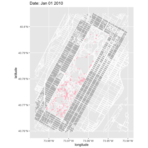
As there is a huge number of photos that were taken in the public parks uploaded on Flickr, the Flickr dataset with geolocation can not only represent the distribution of visitors in the landscape but also provide a new perspective for us to understand the hotspot area, where people are more likely to gather in parks. During the pandemic of COVID-19, social distance becomes necessary and some parks are partly or entirely closed for public health. Studying the hotspot area in the parks can help figure out people’s preference in park spaces, which may provide reference and evidence for landscape planners and designers to think how to modified space and for park managers to think how to plan closure or limitation for the certain space for dealing the challenge of COVID-19. [read more ]
Urban Park Proximity

Taking the parks in Guangahou’s core urban areas as the research object. The study area includes four main districts of Guangzhou, and 68 city parks with 1 hectares or more are selected as study objects. The frequency of park visits is described by Micro-blog check-in data, which include individuals coordinate info. So, the points within areas of the study parka can indicate the location of every visitor in the parks. The more points are in parks, the higher frequency of visits the park. [read more ]
From Risk to Productivity: A Successional Salty Agriculture System in the Pearl River Delta [2019 ASLA Student Awards]

Based on the traditional reclamation agricultural model, our proposal is to integrate agriculture production with wetland transformation under sea-level rise to create a successional salty agriculture landscape adapting to coastal environmental change and benefit agriculture, ecology, and social culture for the next 100 years. [read more ]
From Risk to Resilience: Assessment and Strategy of Complex Urban System Future Sea-level Rise in Guangzhou [2019 IFLA Asia-Pac Professional Award of Excellence]

Based on the feature scenarios of sea level rise and the PSR (Preasure-State-Response) model, the vulnerability of various systems in the coastal area of Guangzhou was evaluated. The proposed landscape planning guidance aims to enhance the resilience and ecological services of the coastal systems. [read more ]